Monday, June 4, 2012

Kaiate Falls, Bay of Plenty


What: 45 min loop walk via the bottom of the Kaiate Falls


Where: 7km down Waitao Rd, off Welcome Bay Rd


When: Any time of year


How: The entrance to this track is well sign posted from the car park. In the first few minutes you will be led to where the Kaiate stream drops over a small bluff and begins its cascade into 9 magnificent waterfalls. From here the track continues down to the base of the falls via a series of steep steps. Along the way there are plenty of places to stop and enjoy the views of these falls. Be sure not to miss the zigzagging trio of falls mid way down. As you near the bottom you will be able to hear the power of the bottom waterfall as it hits the waterhole below. This is a great swimming hole to cool off in on a hot summers day.


From here, a bridge crosses the stream and you can either continue on the loop back up to the top or head down stream for another 50m or so to a variety of small swimming holes. If your fitness isn't what it should be as you climb up the stairs, there are plenty of places to rest and enjoy the beautiful views. Make sure you take time to admire the lovely big puriri and kohekohe trees.


Above the car park is a picnic area where you can enjoy the views of the Port of Tauranga and Mount Maunganui.

William Wright Falls, Waihi

What: 2-2.5 hours return walk to the bottom of William Wright Falls

Where: Track starts from northern end of Waihi Beach, off Waihi Beach Rd

When: Any time of year (summer for swimming)

How: This popular walking track boasts spectacular panoramic coastal views, mature native bush, great rock fishing and plenty of picnic spots along the way.


This track is well marked from the Northern end of Waihi Beach. Access to the start of the track may occasionally be delayed due to high tides and a strong swell. The gently rising track winds around the headland to a lookout point where there are breathtaking views of Mt Maunganui and Mayor Island. A steep descent will lead you to a beautiful, pohutakawa lined, white sandy beach - Orokawa Bay. Although this beach is not considered safe for swimming due to the steep grade of the sea floor, is it a picturesque spot for a picnic.


At the northern end of this beach,above the Orokawa Stream there is an area where the track to the William Wright Falls begins. The easiest way to cross the stream without getting your feet wet is to walk downstream a bit further to find the narrowest part and practice your long jump!


This slightly undulating track is surrounded in luscious native bush; featuring many nikau palms and an abundance of bird life as you wind your way up the river towards the falls. There are 12 river crossings to complete and if you chose to do this walk after a big rain fall, you will most likely be wading in the water!


At the end of the track you will reach the stunning 30m high, William Wright Falls. During those warmer days these falls would be an ideal place to cool off. There are also several small swimming holes along the way.

Return to Waihi Beach via same route!


Sunday, May 20, 2012

Adrenalin Forest, TECT All Terrain Park, Western BOP

What: Adrenalin pumping high ropes course amongst the Pine Trees, 3 hours to complete as many of the six pathway challenges as you can!

When: Anytime of year (best with little or no wind)

Where: TECT All Terrain Park, located off SH36, the main road link between Tauranga and Rotorua, the park is approximately 20 minutes drive from the outskirts of Tauranga or Rotorua.


How… 
Our group of five arrived at Adrenalin Forest just in time to get ahead of a large group booking of 24 (make sure you book first, they will advise if any large groups are booked in as you do not want to get stuck in a long queue of ‘ropers’!

The staff at Adrenalin Forest were super friendly (not too hard on the eyes) and gave a quick but thorough demonstration on safety and equipment basics before directing us towards our warm-up on pathway one – ‘Discovery’.  

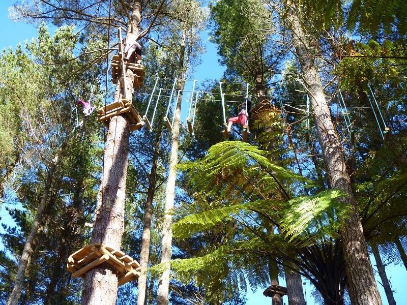
The ropes forest consists of six pathways which progress in difficulty. Each pathway varies in height and holds a number of different challenges, most of which include you walking, swinging or leaping along an assortment of suspended rope and log obstacles. As you progress through the course the pathways increase in the number of challenges and height and become more physically demanding.  Within each course there are also several flying fox sections where you can rest the arms and zoom across to the next step via a flying fox apparatus attached to your harness.

After completely levels one and two with relative ease we decided to skip to level five and get some real adrenalin pumping.  At a height of 15m this was a fair jump from the 6m max height in level 2 and substantially harder on the arms!  Peer-pressure dominated my slight fear of heights and I found myself well out of my comfort zone walking over tightropes, swinging logs, rope swings and numerous other obstacles suspended at 15m between the pines.  

The ground was a sweet sight at the end of level five but with my fear of heights conquered (or over-run by adrenalin) I was now amped for the highest level – 6.  Level six wasn’t a huge height jump from Level five at 18m but was definitely more physically demanding drawing upon a lot of core and upper-body strength.  On completion of level six the group then returned to complete level 3 and 4.  It should be noted that there is a reason for completing the levels in order as the lower levels tend to contain some of the same or very similar obstacles as the higher levels which allows you to discover the best way to conquer the challenge at a lower height before moving upward!

From monkey bridges to spinning logs, spider-nets, suspended oil barrel tunnels and even a snowboard slider, the challenges were a reflection of the great kiwi sense of ingenuity and adventure.  With levels to suit all ages and fear levels I would highly recommend this as a fun afternoon out with friends and family or for some good old group/team building! 

Why not make a day of it an take along the mountain bikes - TECT All Terrain Park has a range of trails to bike or run with further trail development underway!

Friday, May 18, 2012

Karangahake Gorge Walk

What: The Karangahake Gorge walk is now part of the Hauraki Rail Trail; popular with both walkers and cyclists.  We explored this great track by walking the 14km return track from Waikino Visitor Centre to Karangahake.

When: Any time of year.  Warm weather is perfect to incorporate this walk with a trip to the nearby Waihi Beach.

Where: This track is situated between Paeroa and Waihi.  The track can be accessed from either Karangahake or Waikino.  As we wanted to cover a bit of distance, we decided to start at Waikino Visitor centre and walk back towards Karangahake.

How...

We started this walk at about 9am in the morning, heading towards Karangahake.  After a very short walk, we arrived at the site of the Victoria Battery.  Pictures and information provided on signposts bring the area to life and provide an insight of what the area looked like in the bustling gold-mining days. 

After a short stop at the Victoria Battery, we then walked at a steady pace for an hour until we reached the popular rail tunnel.  The track until this spot was flat and easy, which would make it perfect to get out on the bikes with family or friends.  The tunnel itself was long and eerie and after walking almost a kilometre underground we arrived at Karangahake village.

From here, there are many places to explore and we decided to get back underground and see the 'underground pump station' and the 'windows walk'.  If you decide to do this walk, it is well worth checking out these places - so bring a torch!  It is a short walk from Karangahake to see these awesome places, and well worth it to follow the tracks through the old mining tunnels. 

The 'windows walk' is exactly how it sounds.  A walk through the mining tunnels with opportunities to look out through the 'windows' of the cliff face over the scenery of rapids and native bush. 

We then headed back to Karangahake for a quick break before doing the return trip back through the rail tunnel and gravel track to the car.  Coffee and cake at a cafe at nearby Waihi made for the perfect end to a great morning of exploring this awesome area.

Karangahake Gorge is approxiamately 1h 15min from Hamilton.

Sunday, May 13, 2012

Wairere Falls


What: 2.5-3 hour return tramp to the top of the Wairere Falls (highest waterfall in the North Island)


When: Anytime of year (Summer for swimming)


Where: Goodwin Road, Te Aroha


How… 
This track boasts an array of beautiful sceneries, full of moss-covered rocks, native forest, clear streams, baby waterfalls and the stunning 153m high Wairere Falls.  


The track was well marked and maintained and easily found following the DOC signs from the carpark on Goodwin Road.  Moss-covered rocks and an assortment of tree root-steps made up the first part of the track as it wound towards the river.  As the track reached the river a series of bridges assisted with river crossings, providing great views of the baby ‘river falls’ along the way.  


After the bridges the ascent steepened with a long staircase leading to the top of the gorge.  A few minutes further through the bush and we reached the Wairere Falls lookout (signposted – about 2 minutes off the main track).  The platform looks out from the base of the falls and provided some great snaps of the majestic falls.  


From the lookout the ascent to the top of the falls grew substantially steeper with plenty of stairs to keep the heart rate up. The last ten minutes or so of the track to the  summit was a welcome flat path through more gorgeous bush, finally reaching the crystal clear waters flowing down from the top of the Kaimais (probably drinkable!).  


The summit platform provides expansive views of the surrounding valley and Waikato Farmland and the river looks most inviting with several small water holes for those hot summer days (just don’t get too close to the edge of the falls!).  


The return walk follows the same track back to the carpark on Goodwin Road with the descent taking about half as long as the climb!


Saturday, May 5, 2012

Kayak Fishing Tour, Papamoa

What: Kayak Fishing Tour at Papamoa beach with Tim from NZ Kayaker.com     


When: Year-round - the fish are always there! (wetsuit/thermals recommended in winter!)


Where: Tours run from Papamoa, Mt. Maunganui, or Tauranga Harbour


How...

A beautiful, clear April afternoon made for near-perfect kayak fishing conditions, with the only threat being the small waves on the Papamoa coastline making for a slightly more challenging paddle out.  Before setting off on the fishing tour, our friendly instructor Tim gave us the down-low on how to work the kayaks and fishing gear.  A thorough demonstration covered all aspects of the ensuing trip from paddling tips, to casting and lure techniques. After giving us some pointers on how to paddle and balance through the waves, Tim sent us off one-by-one instructing us to paddle as quickly as possible through the breaking waves.  


The solid fishing kayaks sailed easily over the breaking waves, minus a slight misjudgement of the first wave which managed to tip me out upon entry (wetsuit recommended!).  After meeting Tim beyond the breakers we then began to paddle in the general direction of Motiti Island.  After a 30-40 minute paddle Tim’s fish radar seemed satisfied and he then assisted us to release our sea anchors and cast out our rods!  


The next few hours were spent casting, fishing, chatting and enjoying the sights of the Mount Mauganui and Papamoa coastline.  Along with useful fishing tips, Tim provided great conversation with lot’s of exciting stories to share from his recent solo circumnavigation of NZ by kayak.  Fish-wise the afternoon was a little quieter than usual with a few bites, a few undersized throw-backs and Kelly being the only one to land some decent-sized snapper.  However, the lack of fish didn’t dampen the fun afternoon in the sun and Tim kindly gave us a plateful of fresh snapper fillets each to take home - part of his bounty from a more successful trip the day before!


If you are interested in one of these kayak fishing tours visit www.nzkayaker.com for more details, email tim@nzkayaker.com, or ring Tim direct on 027 668 9904.  Tim is currently running an introductory special of $50 per person for a 4hr fishing tour so get in fast!!


Monday, April 23, 2012

Bell Rock Walk, Hawke's Bay

What: 2-2.5hr return walk to Bell Rock, panoramic views overlooking the beautiful Hawke's Bay ranges


When: Any time of year (just make sure its a clear day!)


Where: Pohokura Road, Approximately one hour north of Napier


How...


Bell Rock is a beautiful walk through a mixture of lush NZ bush and open farmland.  After hearing of the Bell Rock look out with its views over the Kaweka mountain ranges and Hawke's Bay coastline, we decided this would be the perfect chance to stretch our legs on a four-hour drive from Tauranga to Napier.  Unfortunately, the overcast weather this day did not agree with our plans to capture the panoramic sights that can normally be seen from Bell Rock. However, the mist provided an element of enchantment and to the bush, and Bell Rock in thick fog was an eerie experience, with all sights hidden beyond the massive rocky outcrop.  


The start of the Bell Rock walk is a decent drive off the main highway and there were several small landslips along the windy gravel Pohukura Road, so care should be taken!  When you pass a rocky formation in a paddock to your left you have almost reached the entrance to the Bell Rock walk.  Continue down the road for a further few minutes and you will see the Bell Rock walk track signposted on your right.  There is lots of room to park on the grassy verges next to the track start.  


The walk itself started as a gentle undulating path through beech and podocarp forest. A symphony of native bird calls provided some sweet background music with the chatter of tui, bellbird and kereru often heard here.  After  30-40minutes the path emerged onto open farmland with painted green DOC posts marking the rest of the track (about 30 mins) through the paddocks towards Bell Rock.  Bell Rock is a massive rocky outcrop, and the ridges of this outcrop are fun to explore but slippery when wet!  The return trip is via the same track, just make sure to keep track of the green posts when heading back through the paddocks!


Pohukura Road can be accessed from State Highway 5 (Napier-Taupo road) via Waitara road, if coming from Taupo.  If heading up from Napier, head towards Tutira and take a left onto Matahorua Road and a second left onto Pohokura Road.  If heading from Taupo don't miss the turn-off to the Waipunga falls lookout on Napier-Taupo road (signposted, just off the main highway).  This triple-waterfall is a spectacular sight after some heavy rainfall!

Monday, April 16, 2012

Full moon tramp, Mt Egmont, Taranaki


What: 4 hours to summit, 8 hours return
When: Summer is best (very dangerous in the winter months)
Where: From New Plymouth it's about a 30 minute drive. Head south on State Highway 3 to Egmont  Village and turn right onto Egmont Road. The track access point is at the North Egmont Visitor Centre.


How... 
You can choose to either do a day tramp or if you are lucky enough, a full moon tramp, starting at around 2am. It's pretty tough work climbing the mountain so would not recommend starting after about 10am. We decided to do the moonlight tramp so we could watch the famous sunrise. We met up at the visitors centre at 2am, kitted with headlamps, thermals and plenty of food and water. I would highly advise if you choose to do the moonlight walk to go with an experienced climber as this mountain is definitely not one to mess with!


To begin, climb the stile over the locked gate and wind your way up the gravel road to the private hut. The last public toilets on your way up are found here. Continue up the steps through the rock covered Hongi Valley. This will lead onto the steep scoria slopes where you will be going two steps up and one step back. There is no track from here, so you just aim for the summit. Eventually you will get to the Lizard (2314m) which is a prominent rocky ridge. Here, it is vital to watch and warn others of falling rocks both above and below you. This is probably one of the most difficult and dangerous parts of the climb, as sections of this route involve almost free-style rock climbing. Some rocks may look stable to climb on, but can easily become dislodged. It is also about the stage in the climb where your legs become very fatigued and heavy. After about 3.5hours of straight climbing you will reach the crater entrance. The crater is covered in ice year round; this can be a bit slippery so take your time while on it. After crossing the crater there is another 30minutes of clambering up rocks to reach the summit (2518m). 


I can't even begin to describe the incredible feeling of reaching the summit. On a fine day you will be rewarded with views of as far as Mt Ruapehu. Watching the sunrise from the summit is probably the most amazing thing I have seen while out tramping. You are up so high that the earth looks rounded and as the sun breaks you are surrounded by spectacular changes in the colours of the sky. If you look north as the sun is rising you might be lucky enough to see the shadow of Mount Taranaki on the ocean!


To return, head back down the same way you came up. The trip down is a lot faster and easier than on the way up so take your time ad enjoy the beautiful views in the sunshine.


This tramp is rated as the most difficult day tramp in New Zealand. It has also taken peoples lives, so don't take safety lightly. Make sure you have plenty of warm clothes for when you are at the summit. We went in the peak of summer and were still freezing wearing 3 thermals and a windproof jacket! Lots of short breaks are vital to allow you to stay focused while climbing. Take at least 1.5 litres of water and plenty of food. The weather can change rapidly on this mountain so if the weather takes a turn for the worst, head back down. The mountain will still be there tomorrow!

Rainbow Mountain Summit Walk


What: 2hr-ish return walk to the top of Rainbow Mountain      
When: Anytime of year
Where: Rainbow Mountain lies 26 km south-east of Rotorua, beside the Rotorua-Taupo highway (SH5). Approaching from Rotorua the carpark is located just past the turnoff for SH 38, on the left-hand side of the road.

How…


Rainbow Mountain is a great place to stop and stretch the legs on a long journey whilst catching some spectacular 360 views across the Rotorua lakes, and mountains of the Central Plateau.  From the carpark on SH5, follow the signs to the crater lakes lookout.  After a 10-15 minute walk, the viewing platform here provides a peek of the stunning emerald lakes and unusually coloured brown, orange, and red surrounding rock-faces. 


From here, the track to the summit continues upward through a mixture of native bush and bare ridges providing regular views of the crater lakes and surrounding countryside along the way.  The final part of the track emerges onto the dirt and gravel summit road which will take you the remainder of the way to the top. 

From the summit Mt Tarawera, Lakes Tarawera, Rotomahana and Rerewhakaaitu can be seen to the north, the Paeroa Range to the west,  Urewera Ranges and Kaimanawa Forest to the east,  and Mt Tauhara, Lake Taupo and the volcanic peaks of Tongariro National Park to the south.  The summit  provides a nice flat picnic area to take in the views, or for a slightly better view, ask the man in the fire-watch house nicely and he’ll invite you up for a view from the deck.  

Sore muscles?  After returning to the carpark, drive a few minutes further down SH5 and take the turn off to Kerosene Creek.  A few minutes down the gravel road will lead you to a carpark with the thermal creek running alongside it.  Walk as far as you like until you find a spot you fancy.  This natural wonder forms from a hot spring flowing down through natural bush, pouring over an old lava flow.  With a range of bathing spots along the river this is a great place to come with a group of friends or perhaps a romantic spa (if you don't mind the 'slight' smell).     

Whataroa Falls Walk, Bay of Plenty


What: 1 1/2-2hr return walk to the Whataroa Falls         
When: Anytime! (Less slippery in summer)
Where: Mountain Road, off Oropi Road (South from Tauranga)

How…

This pretty bush-walk makes for a nice summer’s afternoon activity and is an easy track for people of all ages.  The start of this track follows the Rimu loop track, which is well-sign posted opposite the picnic shelter on Mountain Road.  After about 10 minutes on the Rimu track a sign-post will direct you onto the Whataroa fall track.  The path to the falls undulates through beautiful, dense native bush and while an easy track it can be slippery in parts, especially following heavy rainfall.  At the falls there are several large flat rocks making for a great picnic spot, and the waterhole under the fall is an inviting swim for those warmer days.  The walk follows the same track back to the start, and an ancient fallen Kauri is a cool sight to check out on the way back to the Carpark. 
 
The Whataroa falls track is approximately a 40min drive from Tauranga


Saturday, April 14, 2012

Wild foods Festival - Hokitika

What: A festival where the main attraction is food and drink that you would not usually consume. 
When: 9th of March
Where: Hokitika, West coast
How...
Hokitika is about a three and a half hour drive from Christchurch, with absolutely stunning views as you cross over Arthur's Pass National Park. The festival begins on the Friday night and continues until the early hours of Sunday morning. The main attraction is the Saturday festival, which starts at 10am and finishes at 5pm. The population of Hokitika quadruples during this weekend, with up to 18,000 people attending the festival. There is a range of accommodation available in Hokitika, however, it does need to be booked well in advance. For people travelling on a budget, many of the local schools become camp grounds over the weekend. Dressing up is highly encouraged and the "best dressed" receives a $1000 travel voucher.

The Wild Food Festival is famous for the special West Coast food that is on offer. At the festival you will find things such as huhu grubs, crickets, mountain oysters (aka sheep testicles), brain, vertebrae, duck stomach, horse semen, pukeko, raw tuna, gourmet garden snails, colostrum desserts, moonshine and elderflower and rhubarb champagne. There is also plenty of West Coast whitebait and fresh berry desserts for those not so keen to try the interesting wild foods. The food is reasonably priced, between $1 and $5. To wash down the wild foods there is plenty of local Monteiths beer on tap. 


As the sun goes down many people head to the beach, which was covered in bonfires for as far as you can see. Here, you can have a few drinks and socialise with the other hundreds of other festival goers. The following morning there is a mass exit from the town. It is definitely recommended to either get up early, or else stay in Hokitika for the day and explore this beautiful West Coast mining town.

Friday, April 13, 2012

The Waikato River Trails - Arapuni section


What: 2h ish mountain bike ride along the Arapuni section of the Waikato River trails (can also walk this)
When: Anytime of year
Where: Arapuni village is 10min from Putaruru, or approx 45min from Hamilton.
How..
We parked our vehicle outside the Rhubarb Cafe, Arapuni village. We then headed a few kilometres out of the village towards Putaruru until we came to Horahora Road. Along Horahora Road, we enjoyed a sweet long downhill then scenic flat tarseal before arriving at the Little Waipa Domain. The domain is a cute camping spot lying next to the Waikato River and is where the riverside section of the trail begins.
The next section to the Arapuni Dam is an undulating ride comprising of gravel and boardwalk and is suitable for riders of all fitness levels. There are many scenic picnic spots and great photo opportunities along this section. The path reaches Powerhouse Road just before the Arapuni Dam. We biked across the road bridge and up the right side of the river, crossing the Arapuni swingbridge to get back onto the trail. This next part of the trail provides some tougher hill sections until you reach the road at the south end of Lake Arapuni.
The section from this road to Jones Landing is recommended for advanced riders and walkers only as the steep climbs and tight downhills are not easy. However, this section can be easily completed with a combination of biking and walking and is well worth it for the views it provides over Lake Arapuni. Upon reaching Jones Landing, we turned around and headed back towards Arapuni village. There is the option to go further with the trails towards the Waipapa Dam. It is roughly 20min of road cycling alongside gorgeous farmland back to the village.
The Rhubarb Cafe in Arapuni Village is the perfect way to end your ride. The cafe also offers 'cruiser' bikes for hire.

Te Waihou Walkway - Putaruru, South Waikato


What: 2.5hour easy walk along the Te Waihou Stream
When: Anytime of year - though a hot summer's day would be perfect to take a dip after the walk in the swimming hole at the carpark off White Road (SH28).
Where: 5min drive from the Putaruru township - off SH28 heading towards Rotorua.
How...
Living in Hamilton and in need of a free activity to change up your Sunday afternoon? Take a trip out to Putaruru and do this 9ish km return walk alongside the Te Waihou Stream (home of 'Pump' water).
We parked our car at the White Road carpark. The walk to the stunning blue spring is a flat, easy walk over a combination of bush track and farm paddock. The walk includes a loop track where you can take the scenic boardwalk along the stream.
The Te Waihou stream is unique with its 'blue spring' - where small trout can be spotted within its stunning clear water. Alongside the blue spring is a selection of picnic spots, where families enjoy a nice day out amongst the beautiful scenery that the South Waikato has to offer.
The Te Waihou Walkway is approximately 45min drive from Hamilton.