Sunday, March 18, 2012

Maungatautari Summit Hike, Maungatautari Scenic Reserve

What: Five hour-ish return hike to the Maungatautari Summit and Pukeatua Peak from Tari Road Entrance (Maungatautari is the largest ecological island on mainland New Zealand with 47km of pest-proof fencing providing a haven for native bird and plant-life).
When: Summertime (year round is fine although would be a bit slippery when wet!)
Where: Leave from Tari Road entrance, Pukeatua.  


How...


We were greeted at the Tari road entrance by a couple of DOC volunteers who persuaded us to check out the Southern Enclosure before embarking on our ascent to the summit.  This recommendation proved to be worthwhile as the 30-minute loop track around the Southern Enclosure provided encounters with several native birds and a good warm-up for the legs.  The viewing platform or 'canopy tower' also provided some nice views atop the forest sub-canopy in the Southern Enclosure.


After completing the loop we then followed the well-signposted track towards the maungatautari summit, an estimated 2.5 hour walk.  The start of the track follows several hundred meters of gravel road before entering the bush.  The walk was fairly straightforward, an undulating gradual climb, well-marked, mostly-gravel track through lush native bush up to the summit (note that we took the 'new' track up to the summit - the old track provides a more challenging hike through the undergrowth and can be found following signposts to the 'old track').  Native birds were seldom or heard along this part of the track, with our major wildlife encounter being that of a lone weta strolling across our path.  The last few hundred meters up to the summit brought a change in the surrounding bush scenery with the dense bush giving way to beech trees lining the wooden track.  The summit itself provides little in the way of views with surrounding bush blocking views even from atop the trig station, however a picnic table provides a nice lunch spot to rest before returning to the track.  


On the return hike we took the turn off to Pukeatua peak, a scramble up rocks for about 15 minutes off the main track.  The rock climb is well worth it with the Pukeatua summit providing stunning 360 views of the Kaimai ranges, Pirongia, Kairoi and the Waikato River.  The sky was a little overcast but apparently on a clear day views extend to Ruapehu and Taranaki!  


Once back on the main track the return walk is an easy undulating downhill back to the Tari road carpark.  If driving back towards Cambridge, a stop off in Arapuni is worthwhile to check out the (in)famous Arapuni swing-bridge, which provides some sweet views of the surrounding gorge! Arapuni also provides some great mountain bike tracks and cycleways along the banks of the Waikato River, a biking adventure for another day! ..Another great discovery on this trip was that of the Rollin Ice Cream Parlour, on the main street when driving through Tirau.  The home-made wildberry frozen yoghurt was a refreshing post-hike treat!

Pinnacles Tramp, Kauaeranga Valley, Coromandel

What: 5-6 hour day hike (or can stay in Pinnacles Hut overnight for approx. $15 per person, book in advance!)
When: Summertime is best! (track can get a bit boggy in winter)
Where: Turn off to Kauaeranga Valley Road, 2km south of Thames, North Island, NZ.  


How...


Finding the start-point to the track proved to be one of the trickiest parts of the hike! Kauaeranga Valley Road is long, windy, and rather dusty (car will most definitely need a wash afterwards!)..13km down the road is the DOC visitors centre which is the go-to for any information  on the valley and it's tracks.  Upon reaching the centre we thought we had reached the start of the track, but don't be fooled, starting here adds another 8km to the hike, so once you have checked out the visitors centre, hop back in the car and continue down the the road for about 8km to the road end, you will pass several camp grounds and picnic areas along the way.  


After squeezing the car into a non-existent carpark at the road end(track is very popular in the summer!!), we set off on the gravel track towards to the Kauaeranga River crossing.  This first part of the track is a slight gradient making for a leisurely stroll through native Kauri forest.  Upon reaching the river it can be crossed in one of two ways - via swing-bridge or rock-hopping, depending on the river level! After a quick game of swing-bridge see-saw (sorry DOC), it was time to tackle the stairs which seemed to dominate the rest of the ascent.  


After a solid hour of step workout and a couple more swing-bridges we reached 'Hydro Camp', a base used by workers to erecting power lines over the range seventy-odd years ago. Hydro Camp is a nice clearing with some make-shift log seats, a creek, and a good place to refuel if needed. 


The ascent from Hydro Camp to the Pinnacles Hut was a a further 40 minutes through Kauri forest, finally breaching the tops of the Coromandel Range, catching some breathtaking views of the ranges and a glimpse of the Pinnacles themselves.  


As we were just doing the day hike we bypassed the Pinnacles Hut and began the steep climb up the Pinnacles.  With looming staircases, steep rock faces and several ladders, this part of the hike was definitely the most challenging.  However, once the rocks were scaled and the top reached we were rewarded by epic panoramic views over the Coromandel Peninsula and surrounding ranges.  To the east Tairua/Pauanui can be spotted with views of the firth of Thames to the west.  The day we went up was cloudy and overcast so with views like that I can only imagine how spectacular it would look on a clear day!


The return trip to the start of the track took about 1.5 hours, with the stairs looking a lot more attractive from the top down! An awesome day tramp although will definitely be booking into the Pinnacles Hut for an overnighter next time as I imagine the sunrise from the Pinnacles would be quite spectacular!


Saturday, March 17, 2012

42 Traverse - Central Plateau


What: 52km mountain bike across the State 42 Forest
When: Requires a good level of fitness and reasonable level of technique, so after a little training

Where:
Central Plateau, North Island. The track starts about 15min north of National Park Village and finishes at Owhango. Bikes and transport can be arranged through the backpackers at National Park Village, or take your own bikes and arrange a drop off and a pick up.

How..
We arrived at the start of the track (Kapoors Rd carpark) just before midday. The first 30min of the track is flat, easy and primarily gravel until you reach Pumice Pit. There is a carpark here also, giving you the option to take 30min off the journey, but I recommend biking this first bit as it allows you to warm up with some flat track before getting to some reasonably hilly sections.


The next section to the Waione Stream crossing has a lot of downhill as the track drops off the plateau. This section was my personal favourite as my confidence and technique were both challenged dropping
down the very steep parts of the track. 1h30min into our ride, we reached the Waione Stream - a great place to stop for a sugar fix to fuel the body for the testing hill section to the next stream crossing.


After the quick uphill and a steep descent to the next stream crossing, the hard work really begins. The next section is a long, gradual uphill that really tests the quads, but you are rewarded by great views of the forested limestone country and a peak of the Whanganui River in the valley below.

The last stretch of track before the Whakapapa river bridge has plenty of gradual uphill, quick downhills (including some technical drops through mud) and a couple more stream crossings before reaching the last easy downhill 4km to the bridge. After much uphill mountain biking, this downhill stretch is a nice relief and includes a bridge crossing next to a pretty waterfall. We finished at the Whakapapa river 4.5h after we started, however technically the track ends at the pub in Owhango - a further 20min ride from the river. By the end of the ride, we were exhausted and my bike was a bit worse for wear, but were ecstatic to have completed an amazing ride though an awesome part of the country.

(If you are driving back through Taumaranui after the ride, stop off at the Whanganui River for a dip to rejuvenate the aching legs)


Friday, March 16, 2012

Tongariro Crossing - Central Plateau


What: 19km hike across Tongariro National Park
When: Summertime - before the snow sets in
Where: Central Plateau, North Island. The start and end of the hike is a 40min (ish) shuttle ride from National Park Village. The shuttle can be booked from the backpacking lodges in the village and is $30.

How...

Our trek across the volcanic playground began at the shuttle's drop off point - the Mangatepopo car park. After hiking along a very slight gradient, we passed the Soda Springs and ascended the Devil's Staircase. This part of the hike was rushed

as we were aiming to get to the top of Mt Ngaruahoe by 11am - but if you were just doing the crossing, it would be well worth doing this at a leisurely pace.

After climbing the Devil's staircase, we reached the turn-off for the Mt Ngaruahoe ascent. Don't be disheartened by the first third of this climb. The scree slope makes climbing challenging with a 'two steps forward,
one step back' pace. It does get easier.. soon the scree turns into larger rocks and you get a chance to do a bit of easy rock climbing..

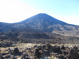
At last (1h 1/2 later) we reached the summit. We joined the other tourists for a bite to eat, photos, and a peer into the crater. We then walked around the crater rim, past steaming vents, before making the steep descent back to the crossing track. The scree slide down Mt Ngaruahoe is worth a trip in itself! Divide the time it took you to get up to the crater by five and that's how long it takes to get down. Running, jumping, sliding and 'arsing over' down the mountain, we got back to the crossing track just after midday. Now it was time to say goodbye to Mt Doom (yes, Mt Ngaruahoe is the star of the Lord of the Rings) and get reaquainted with the Tongariro Crossing.

After a little more of an ascent, the legs get a bit of a rest with a long stretch of flat before the climb up to the red crater. The climb is tough with dead legs from Mt Ngaruahoe but you
are
rewarded with a steep descent down to the Emerald Lakes - the perfect lunch spot. After the Emerald Lakes the trek gets easier and primarily downhill, with awesome views all the way. By the end of the journey, there are guarantees of exhausted legs, camera choc with photos and great memories. Enjoy!

The Tongariro Crossing is approximately 4h from Auckland, 2.5h from Hamilton and 3.5h from Wellington.